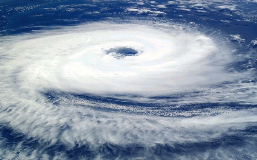
Hurricane Beryl has intensified into a “potentially catastrophic” Category 5 storm, the United States’s National Hurricane Center (NHC) said, as it headed towards Jamaica after bringing down power lines, damaging houses and flooding streets on other southeastern Caribbean islands.
Beryl, the earliest Category 4 storm ever reported, made landfall earlier on Monday on the island of Carriacou in Grenada.
Carriacou took a direct hit early in the day from the storm’s “extremely dangerous eyewall,” with sustained winds at upwards of 240 km per hour (150 mph).
Nearby islands, including Grenada, St. Vincent and the Grenadines, also experienced “catastrophic winds and life-threatening storm surge”, the hurricane centre said.
Grenada’s Prime Minister Dickon Mitchell told a news conference, that in half an hour, Carriacou was flattened. He said one person had died, but authorities had not yet been able to assess the situation on the islands of Carriacou and Petite Martinique, where communications had been largely cut off.
Streets from St. Lucia Island south to Grenada were strewn with shoes, trees, downed power lines and other debris. Some banana trees were snapped in half by the force of the wind.
The storm is expected to pass near Jamaica on Wednesday, the Miami-based hurricane centre said.
Jamaica’s government issued a hurricane warning for the country, while tropical storm warnings were in effect for parts of the southern coasts of the Dominican Republic and Haiti.
The last strong hurricane to hit the southeast Caribbean was Hurricane Ivan 20 years ago, which killed dozens of people in Grenada.
Beryl became the first hurricane of the 2024 Atlantic season on Saturday and quickly strengthened to Category 4.
Experts say that such a powerful storm forming this early in the Atlantic hurricane season, which runs from early June to late November, is extremely rare and that climate change probably contributed to its rapid formation.
Global warming has helped push temperatures in the North Atlantic to all-time highs, causing more surface water to evaporate, which in turn provides additional fuel for more intense hurricanes with higher wind speeds.
Andra Garner, a New Jersey-based meteorologist, noted that Beryl jumped from a Category 1 to a Category 4 storm in less than 10 hours.
Her research has shown that as water temperatures have risen over the last five decades, it has become more than twice as likely for storms to jump from weak storms to major hurricanes in less than 24 hours.
In May, the US National Oceanic and Atmospheric Administration predicted above-normal hurricane activity in the Atlantic this year, also pointing to unseasonably high ocean temperatures.
Across other islands in the eastern Caribbean, residents had boarded up windows, stocked up on food and filled their cars with fuel as the storm drew closer.
Officials in Mexico also began to prepare for Beryl’s arrival later this week, with the federal government issuing a statement urging authorities and the population to exercise “extreme caution.”